Protected: Agricultural Assessment for the Apalachicola-Chattahoochee-Flint(ACF) River Basin
There is no excerpt because this is a protected post.
There is no excerpt because this is a protected post.
There is no excerpt because this is a protected post.
Sponsors: National Science Foundation
Students: Courtney Di Vittorio
Description:
Hydrologic models of wetlands enable hydrologists and water resources managers to appreciate the environmental and societal roles of wetlands and manage them in ways that preserve their integrity and sustain their valuable services. However, wetland model reliability and accuracy are often unsatisfactory due to the complexity of the underlying processes and the lack of adequate in-situ data. In this research, we demonstrate how MODIS satellite imagery can be used to characterize wetland flooding over time and to support the development of more reliable wetland models. We apply this method to the Sudd, a seasonal wetland in South Sudan that is part of the Nile River Basin.
Sponsors: National Science Foundation
Students: Courtney Di Vittorio

Hydrologic models of wetlands enable hydrologists and water resources managers to appreciate the environmental and societal roles of wetlands and manage them in ways that preserve their integrity and sustain their valuable services. However, wetland model reliability and accuracy are often unsatisfactory due to the complexity of the underlying processes and the lack of adequate in-situ data. In this research, we demonstrate how MODIS satellite imagery can be used to characterize wetland flooding over time and to support the development of more reliable wetland models. We apply this method to the Sudd, a seasonal wetland in South Sudan that is part of the Nile River Basin.
The database consists of 16 years of 8-day composite ground surface reflectance data with a 500-m spatial resolution. After masking poor quality pixels, monthly distributions of wetness and vegetation indices were extracted. Based on literature and personal accounts describing the Sudd as well as Google Earth imagery, a set of ground truth locations were identified for nine land classes. Using the ground truth locations, a novel classification procedure was developed that uses the empirical monthly distributions of each individual pixel. This procedure allows pixels to be classified as mixed pixels (or mixels) if their distributions share properties with two different classes. Once the full area of interest was classified, each pixel was evaluated on a monthly scale to determine if, when, and how long it was flooded using a procedure that incorporates spatial information and monthly precipitation data. The result is a set of monthly inundation maps for the full period of interest (2000–2015). An independent set of ground truth locations were selected to validate the land cover classification procedure, which demonstrated a high level of accuracy. The derived monthly inundation series agrees well with existing literature, limited ground observations, and estimated water fluxes into the wetland. This information is currently being used to develop a wetland model as part of a comprehensive modeling system for the Nile River Basin. This novel procedure is general and has many advantages over those in existing research for applications in data scare areas.
Publications:
C. A. Di Vittorio & A. P. Georgakakos. Land cover classification and wetland inundation mapping using MODIS. Remote Sensing of Environment 204, 1-17 (2018). https://doi.org/10.1016/j.rse.2017.11.001
We are grateful to the Ministries of Water and Irrigation in Uganda, Sudan, and Egypt for the provision of in-situ river flow and other hydrologic data. Moreover, we are grateful to Dr. Georg Petersen for sharing his ground measurements on the Sudd Wetland. This research was supported in part by the National Science Foundation Graduate Research Fellowship Program under Grant No. DGE-1650044. Any opinions, findings, and conclusions or recommendations expressed in this article are those of the authors and do not necessarily reflect the views of the National Science Foundation or other organizations.
In watersheds with appreciable water use and regulation (including storage reservoirs, in-stream withdrawals, and/or inter-basin water transfers), the development of reliable ensemble streamflow predictions (ESP) at downstream locations requires characterization and incorporation of the expected streamflow alterations from natural conditions and their associated uncertainty. Streamflow alterations can be incorporated if, as part of the ESP forecast generation process, water use and regulation activities are represented with sufficient accuracy.

In watersheds with appreciable water use and regulation (including storage reservoirs, in-stream withdrawals, and/or inter-basin water transfers), the development of reliable ensemble streamflow predictions (ESP) at downstream locations requires characterization and incorporation of the expected streamflow alterations from natural conditions and their associated uncertainty. Streamflow alterations can be incorporated if, as part of the ESP forecast generation process, water use and regulation activities are represented with sufficient accuracy. This approach can be effective in watersheds where flow alterations occur due to large, main stem river projects and well documented water use activities, but it becomes impractical where flow alterations result from many small and/or medium scale storage projects and water use activities distributed throughout the watershed. In the latter cases, comprehensive information on reservoir filling and depletion, water withdrawals and returns, and/or water transfers is both not readily available and subject to change from year to year, adding bias and uncertainty to the flow forecasts. This research project develops and demonstrates procedures to characterize the aggregate flow alteration biases and uncertainty in watersheds in the latter category and incorporate them in ensemble streamflow predictions at downstream points.
This research project develops and demonstrates a new method to characterize the aggregate flow alteration biases and associated uncertainty in watersheds with important but largely undocumented water use and regulation activities.
The approach includes procedures to (a) detect the presence of significant upstream regulation and water use influences; (b) correct the ensemble streamflow predictions and associated uncertainty for any biases during periods when upstream regulation and water use influences are detected; and (c) assess the forecast reliability improvements. Validation results are reported for three California watersheds. The forecast adjustment approach has been developed for operational use in routine forecast operations of the U.S. National Weather Service River Forecast Centers.
1. Georgakakos, A.P., H. Yao, and K.P. Georgakakos, “Upstream Regulation Effects on Ensemble Streamflow Prediction,” Journal of Hydrology, in press, 2014.
This project was funded by the Hydrologic Research Laboratory of the National Weather Service and was carried out jointly by the Hydrologic Research Center (HRC; California) and the Georgia Water Resources Institute (GWRI; Georgia) in collaboration with the NWS River Forecast Centers.
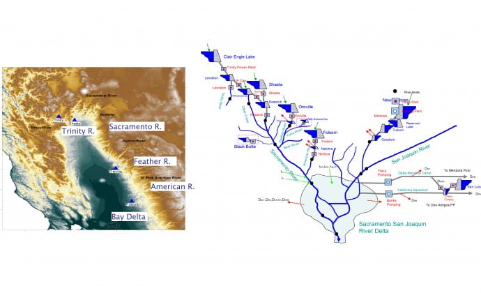
The northern California river system encompasses five major rivers (Trinity, Sacramento, Feather, American, and San Joaquin), five major reservoirs (Trinity, Shasta, Oroville, Folsom, and New Melones), 11 medium to small reservoirs, 12 hydro power plants (of 2,140 MW total generation capacity), 30 water supply nodes and diversions (including the aqueducts to southern California), and the Sacramento-San Joaquin (Bay) Delta, which is the habitat of hundreds of aquatic terrestrial species.

The northern California river system encompasses five major rivers (Trinity, Sacramento, Feather, American, and San Joaquin), five major reservoirs (Trinity, Shasta, Oroville, Folsom, and New Melones), 11 medium to small reservoirs, 12 hydro power plants (of 2,140 MW total generation capacity), 30 water supply nodes and diversions (including the aqueducts to southern California), and the Sacramento-San Joaquin (Bay) Delta, which is the habitat of hundreds of aquatic terrestrial species. The Oroville-Thermalito complex comprises the State Water Project (SWP), while the rest of the system facilities are federal and comprise the Central Valley Project (CVP).
The Northern California River and Reservoir system provides two-thirds of the state’s drinking water, irrigates 7 million acres of the world’s most productive farmland, and is home to hundreds of species of fish, birds, and plants. In addition, the system protects Sacramento and other major cities from flood disasters and contributes significantly to the production of hydroelectric energy. The Sacramento-San Joaquin Delta provides a unique environment and is California’s most important fishery habitat. Water from the Delta is pumped and transported through canals and aqueducts south and west and supports a multitude of vital water uses.
An agreement between the US Department of the Interior, Bureau of Reclamation, and the California Department of Water Resources (1986) provides for the coordinated operation of the SWP and CVP facilities (Agreement of Coordinated Operation-COA). The agreement aims to ensure that each project obtains its share of water from the Delta and protects other beneficial uses in the Delta and the Sacramento Valley. The coordination is structured around the necessity to meet the in-basin use requirements in the Sacramento Valley and the Delta, including Delta outflow and water quality requirements. Under normal hydrological conditions, the inflows from the Sacramento River, San Joaquin River, and the local stream flows can meet the needs of Delta demands and the water export. However, during dry water years, extra water has to be released from the upper major reservoirs to meet the demands. The COA specifies the manner in which the required extra water is shared by the large reservoirs in the Sacramento River basin (Clair Engle Lake [Trinity], Shasta, Oroville, and Folsom).
The Integrated Forecast and Reservoir Management (INFORM) project aims to develop and demonstrate integrated operational methodologies of climate and hydrologic forecasting and reservoir management to support reliable water supply for municipal, industrial, and agricultural users; energy generation; flood protection; recreation; fisheries management; and environmental and ecosystem sustainability.
The INFORM modeling system includes the following components:
1. HRC-GWRI. 2006. Integrated Forecast and Reservoir Management (INFORM) for Northern California: System Development and Initial Demonstration. California Energy Commission, PIER Energy-Related Environmental Research. CEC-500-2006-109. http://www.energy.ca.gov/pier/project_reports/CEC- 500-2006-109.html]
2. HRC-GWRI. 2013. Integrated Forecast and Reservoir Management (INFORM): Enhancements and Demonstration Results for Northern California (2008-2012). California Energy Commission. Publication number: CEC-500-2014-019.
http://www.energy.ca.gov/2014publications/CEC-500-2014-019/CEC-500-2014-019.pdf
3. Georgakakos, K.P., Graham, N.H., Cheng, F.-Y., Spencer, C., Shamir, E., Georgakakos, A.P., Yao, H., and Kistenmacher, M., “Value of Adaptive Water Resources Management in Northern California under Climatic Variability and Change: Dynamic Hydroclimatology,” J. Hydrology, Vol. 412-413, pages 47-65, 2012. Also, on line reference doi:10.1016/j.jhydrol.2011.04.032, 2011.
4. Georgakakos, A.P., Yao, H., Kistenmacher, M., Georgakakos, K.P., Graham, N.H., Cheng, F.-Y., Spencer, C., Shamir, E., “Value of Adaptive Water Resources Management in Northern California under Climatic Variability and Change: Reservoir Management,” J. Hydrology, Vol. 412-413, pages 34-46, 2012. Also, on line reference doi:10.1016/j.jhydrol.2011.04.038, 2011.
5. Kim, D., and A.P. Georgakakos, “A New Nonlinear Hydrologic River Routing Model,” Water Resources Research, in review, 2014.
6. Kistenmacher, M., and A.P. Georgakakos, “Uncertainty Management for Multi-objective and Multi-dimensional Reservoir Systems, Water Resources Research, in review, 2014.
The INFORM project has been funded by the California Energy Commission, the National Oceanic and Atmospheric Administration (NOAA) and CALFED (a consortium of California and federal agencies). The project has been carried out jointly by the Hydrologic Research Center (HRC; California) and the Georgia Water Resources Institute (GWRI; Georgia) in collaboration with the California – Nevada River Forecast Center of the U.S. National Weather Service, U.S. Bureau of Reclamation, California Department of Water Resources, and California Energy Commission.
Additional information on the project activities can be found at http://www.hrc-lab.org/projects/dsp_projectSubPage.php?subpage=inform.
The Nile River
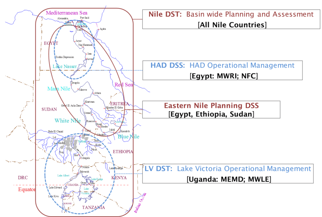
The Nile River Basin (Figure 1) covers about 10% of the African continent and is spread over eleven countries (Burundi, Congo, Egypt, Eritrea, Ethiopia, Kenya, Sudan, South Sudan, Tanzania, Uganda, and Rwanda). Almost all Nile water is generated on an area covering 20 percent of the basin, while the remainder is in arid or semi-arid regions. Egypt and Sudan are almost totally dependent on the Nile for their water uses.
The Nile River Basin (Figure 1) covers about 10% of the African continent and is spread over eleven countries (Burundi, Congo, Egypt, Eritrea, Ethiopia, Kenya, Sudan, South Sudan, Tanzania, Uganda, and Rwanda). Almost all Nile water is generated on an area covering 20 percent of the basin, while the remainder is in arid or semi-arid regions. Egypt and Sudan are almost totally dependent on the Nile for their water uses. Most other Nile countries are close to water stress, if not already below the water scarcity threshold of 1000 m3 of water per inhabitant per year. Water stress is compounded by rapid population growth, occurring at nearly twice the average global rate. Hence severe water scarcity conditions are looming over most Nile countries. Nile Basin economies are heavily dependent on agriculture which accounts for more than half of the gross domestic product and employs more than 80% of the workforce. However, lack of water supply infrastructure, marked climate variability, and poor cultivation practices have seriously restrained, if not completely halted, economic growth.

These complex challenges are at the forefront of ongoing efforts by the Nile Basin nations to set forth equitable and lasting water development and utilization agreements that would enable sustainable economic growth. However, effective policy dialogue requires that the countries assess and weigh the benefits and impacts of various water development and management strategies accrued to themselves and other Nile partners. Pre-requisite elements in this process are the existence of an institutional cooperative framework, information and modelling systems that can assess the value of alternative development and management scenarios, and human resources with expertise to use them effectively.
The Nile Basin technical information needs span a wide range of
(i) sectors (water supply, agriculture, energy, environment, ecology, public health, socio-economics, etc.);
(ii) geographic scales (basin wide, regional, national, and local);
(iii) temporal scales (decadal, annual, seasonal, weekly, daily, and sub-daily);
(iv) decision makers (Nile Basin Ministers; regional multi-country organizations such as those associated with the eastern and southern Nile regions; national water, agriculture, environmental and energy agencies; and local communities); and
(v) decisions (basin infrastructure development projects, water sharing compacts, regional and national management of hydro-systems, and community and catchment scale projects).
The purpose of the GWRI involvement in the Nile Basin over the last two decades has been to develop and transfer such systems to the Nile Basin countries.
The Nile Decision Support Tools (Nile DSTs) are the outgrowth of several research and technology transfer projects implemented in the course of the last 20 years. These were collaborative efforts with the Nile Governments and their agencies and various international organizations. The Nile DSTs include planning and operational management components developed for and used by individual country agencies as well as by regional and basin wide organizations (Figure 2).
A planning level DST, named Nile Decision Support Tool (Nile DST; 2000-2003), was developed and implemented for all 10 Nile countries under the auspices of the Food and Agriculture Organization of the United Nations (FAO) with support from the Italian Government. Operational management DSTs have been developed for and are currently used in Uganda, Tanzania, and Kenya (Lake Victoria DST; 1997-1999 and 2002-2005) under World Bank and FAO support, and Egypt (High Aswan Dam DSS; 1993-1996, and 2003-2005) under support from the US Agency for International Development and the Government of the Netherlands. While these tools were built separately, they share a consistent modeling framework and are designed as components of an integrated system. The Nile DSTs are developed to address the Nile Basin decision making needs and span a wide range of geographic and temporal scales, sectors, decision makers, and policy choices.
The Nile Decision Support Tools combine extensive data bases, Geographic Information Systems, and a suite of interlinked models for climate forecasting, satellite based rainfall estimation, streamflow forecasting, river and reservoir simulation, irrigation planning, river basin management, energy system planning and management, and economic assessment. They are intended to provide engineers, managers, and policy makers with the knowledge to develop and implement sustainable water and energy development and sharing strategies for much needed economic development.
Training and Technology Transfer Activities
Information and decision support systems are advanced science products that cannot be sustained without sufficient human resources qualified to utilize, maintain, and further develop them. As part of the DSS development efforts, GWRI have been working to develop the technical capacity of water resources engineers, managers, and policy makers through intensive hands-on training workshops; study tours and executive seminars; one- and two-semester traineeships in the US; and full enrollment at Georgia Tech’s graduate water resources program. Specifically, more than 75 engineers from all Nile Basin countries have participated in annual training workshops in the course of the last 15 years and have become an important technical resource currently using and maintaining the Nile Decision Support Tools in their respective countries. Intense, two to four week, training workshops have been held annually at various Nile countries (including Egypt, Ethiopia, Tanzania, and Uganda) aiming to provide technical understanding and hands-on application experience on the Nile DST methods and software usage (data management and GIS, climate and hydrologic forecasting, remote sensing, river simulation and reservoir management, agricultural planning, integrated water-energy system planning, economic assessments, etc.). These training activities are having tangible impacts with many of the trained engineers being promoted to leadership positions at various national and regional water resources agencies and organizations.
The GWRI involvement in the Nile Basin has been funded by several international organizations and Nile Basin Governments. These include the Food and Agriculture Organization of the United Nations (FAO-UN), World Bank, U.S. Department of State, US Agency for International Development, US Bureau of Reclamation, Japan International Cooperation Agency (JICA), Sweden International Development Agency (SIDA), Netherlands Ministry of Development Cooperation, Government of Egypt, Government of Tanzania, and Government of Uganda.
Sponsors:
Students:
Short Course
Instructor: Huaming Yao (GWRI/Georgia Tech)
Instructor: Aris Georgakakos (GWRI/Georgia Tech)
Sponsor: GWRI
The Nile Basin is home for 250 million people spread into ten different countries. For all these countries (Egypt, Ethiopia, Sudan, Eritreia, Uganda, Tanzania, Kenya, Rwanda, Burundi, and Congo), the river is life itself, helping to grow crops, sustain livestock, and power economic development. However, the time when the river could generously meet each country’s water needs independently of all the rest is coming to an end, and the need for basin-wide management is becoming clear.
Project Description
Huaming Yao (Research Associate)
Amy Tidwell (Research Associate)
Carlo De Marchi (Research Associate)
Kelly Brumbelow (Research Associate)
Sponsor: UN FAO
Keywords:
Description
The Nile Basin is home for 250 million people spread into ten different countries. For all these countries (Egypt, Ethiopia, Sudan, Eritreia, Uganda, Tanzania, Kenya, Rwanda, Burundi, and Congo), the river is life itself, helping to grow crops, sustain livestock, and power economic development. However, the time when the river could generously meet each country’s water needs independently of all the rest is coming to an end, and the need for basin-wide management is becoming clear. The Georgia Water Resources Institute has been developing a state-of-the-science decision support system that encompasses the river reaches of the White, Blue, and Main Nile branches, along with the existing and proposed water conservation and development projects. The Nile decision support system (Nile-DSS) includes models for inflow forecasting, river and reservoir routing, and reservoir control, and runs on personal computers under a user-friendly, graphical interface. The purpose of the Nile-DSS is to facilitate the Nile Basin Stakeholders in setting forth equitable and lasting water use agreements.
The water resources systems of the Southeastern U.S. are increasingly stressed by various demands. This stress is magnified during the periodic periods of drought that occur in the region, and agriculture is particularly affected by these droughts. Recent public policy has attempted to mitigate the impacts on farmers, but reliable methods of drought assessment and forecasting are needed to allow efficient policy implementation.
Sponsors:
Students:
Sponsor: GWRI
Start Date: 2001-03-01; Completion Date: 2002-02-28;
Keywords: Basinwide planning, Decision support systems, Irrigation assessment, Technical
Abstract:
The water resources systems of the Southeastern U.S. are increasingly stressed by various demands. This stress is magnified during the periodic periods of drought that occur in the region, and agriculture is particularly affected by these droughts. Recent public policy has attempted to mitigate the impacts on farmers, but reliable methods of drought assessment and forecasting are needed to allow efficient policy implementation. A methodology is presented to assess the effects of droughts on crop yields, irrigation demands, and the full yield- irrigation relationship. The technique utilizes irrigation optimization algorithms coupled with physiologically based crop models. Ensembles of climatic forcing allow for quantification of the stochastic crop-water production function at specific sites and quantification of the changes in this function in drought periods. Data needs for assessment are discussed as well as sensitivity of the methodology to some input parameters. The technique is applied to four case study sites in southwestern Georgia, and potentially useful information is derived. Options for drought forecasting are briefly discussed.
Technical Report
Principal Investigator: Aris Georgakakos (GWRI/Georgia Tech)
The purpose of this study is to assess the response of the ACF river basin to biological integrity requirements. These requirements are quantified in a preliminary guidance document drafted by US EPA and the Fish and Wildlife Service (1999).
Sponsors:
Students:
Sponsor: GWRI
Start Date: 2000-04-15; Completion Date: 2002-02-14;
Keywords: Flow requirements, In-stream Biological Integrity, Trade-off Analysis, Interbasin Transfer
Scope of Study:
The purpose of this study is to assess the response of the ACF river basin to biological integrity requirements. These requirements are quantified in a preliminary guidance document drafted by US EPA and the Fish and Wildlife Service (1999).
Technical Report
Principal Investigator: Aris Georgakakos (GWRI/Georgia Tech)