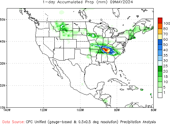
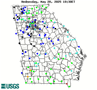
Homepage

  • About the Georgia Water Resources Institute

Latest GWRI News

Agricultural Assessment for the Apalachicola-Chattahoochee-Flint(ACF) River Basin

In this study, bias-corrected and spatio-temporally downscaled climate projections are analyzed to assess how the future climate in the Apalachicola-Chattahoochee-Flint (ACF) River Basin may impact agricultural production and irrigation demand for major crops in the coming decades. This agricultural assessment uses present-day (e.g. year 2023) crop acreages as delineated by the USDA Cropland Data Layer (USDA NASS, 2023) and subjects them to historical and projected daily climate from multiple downscaled and bias-corrected climate models. Climatic hindcasts and projections are based on the Joint Variable Bias Correction with Historical Analog (JVBC-HA) approach. Two Shared Socioeconomic Pathway (SSP) scenarios are considered, the SSP245 scenario featuring mild future greenhouse gas emissions heading into the end of the century, and the SSP585 aggressive emissions scenario. Assessments answer the science question: What kinds of yield and irrigation demand would materialize if present-day agricultural production practices were conditioned under both historical (dating back to year 1988) and projected (extending to year 2095) daily climate?

Continue Reading Agricultural Assessment for the Apalachicola-Chattahoochee-Flint(ACF) River Basin

Climate Assessment for the Southeastern U.S.

In this study, bias-corrected climate projections are analyzed to assess how the future climate in the southeastern U.S. may change in the coming decades. These climatic projections are based on the Joint Variable Bias Correction with Historical Analog (JVBC-HA) approach (Georgakakos & El Sharif, 2024). Two Shared Socioeconomic Pathway (SSP) scenarios are considered, the SSP245 scenario featuring mild future greenhouse gas emissions, and the SSP585 aggressive emissions scenario.

Continue Reading Climate Assessment for the Southeastern U.S.

2023 Biennial Georgia Water Resources Conference – Year 2 (Final Report)

Since its inception in 1989, the biennial Georgia Water Resources Conference has provided an open forum for the discussion of water policies, research, and management strategies within the state of Georgia and surrounding states. The high-profile meeting attracts diverse attendance from government, private, academic and non-profit sectors. The 2023 meeting was the largest ever, with 400 total registrants, 130 oral presentations, 10 panels and 47 posters. The meeting attracted 27 sponsors in addition to GWRI (the lead sponsor); these additional sponsors contributed a total of $30,350. A total of 116 students (mostly graduate and undergraduate, plus a few high school students) attended the meeting.

Continue Reading 2023 Biennial Georgia Water Resources Conference – Year 2 (Final Report)

Evaluating longitudinal declines in water quality in the Conasauga River using aquatic macroinvertebrates

The Conasauga River in Northwest Georgia is nationally recognized for its aquatic biodiversity, much of which is imperiled. The river supports five federally listed fish and seven federally listed mussel species and has been identified as a top priority watershed for conservation in the southeastern USA (Elkins et al. 2019). As many as 30% of the native mussel species in the Conasauga may be extirpated (Evans 2001, Walters et al. 2003), and numerous fish species have declined precipitously in abundance since 2000 (Nagy et al. 2024), including the federally endangered Amber Darter (Percina antesella) and the federally threatened Frecklebelly Madtom (Noturus munitus; Freeman et al. 2017, Stowe et al. 2020). The mechanisms contributing to declining aquatic species have yet to be identified.

Continue Reading Evaluating longitudinal declines in water quality in the Conasauga River using aquatic macroinvertebrates

Uncertainty Analysis of Flooding Drivers in the City of Savannah by an Urban Flooding Model

This study assesses flood variability during different hurricane events along the Savannah River’s fluvial system. To achieve real-time estimations of water surface elevations (WSE) across river channels and reaches, we developed a Physics-Informed Geostatistics Approach (PIGA) that combines reduced spatial correlations derived from a fluvial hydrodynamic model with a Reduced Geostatistical Approach (RGA) based on observational data. A 1D-2D HEC-RAS model was constructed as the physical model for the Savannah River Basin, an area highly susceptible to riverine flooding during hurricane seasons. The performance of the PIGA was compared to the HEC-RAS model across multiple hurricane events, including Hurricanes Matthew, Irma, Dorian, and Idalia. Our study explores the transferability and variability of reduced spatial correlations across different hurricane events, assessing the capability of one event’s spatial data to predict WSE during other events. Results indicate that spatial correlations derived from one hurricane event can reliably predict WSE for other events, with the correlations from Hurricane Irma demonstrating the greatest versatility for our study site. However, significant variability in spatial correlations between hurricane events was also observed, underscoring the need to carefully select the optimal reference event to achieve accurate predictions.

Continue Reading Uncertainty Analysis of Flooding Drivers in the City of Savannah by an Urban Flooding Model

Spatial changes in trace element water chemistry across Piedmont rivers of Georgia with applications for native fish species conservation

Anthropogenic changes to freshwater river systems have impacted native fish and mussel distribution and abundance. Disruptions in movement and migration have led to the declines of many important species in Georgia, including several threatened and endangered species. Furthermore, anthropogenic barriers, physical stream alterations, and reservoir construction may facilitate invasive species expansion and colonization, thereby impacting native species through displacement, disease, and hybridization. The impacts of these human activities – and their relative degrees of influence – vary among river basins and among distinct segments within systems. To help assess the impacts anthropogenic effects have on native species, fish microchemistry can be used to help decipher large scale movement patterns, natal origins and introductions, and habitat use. Trace elements, such as strontium and barium are incorporated into calcified structures of fishes relative to water concentrations. Therefore, quantifying trace element concentrations within and among river systems is a conduit for examining fish behaviors, such as movement and dispersal. The Piedmont ecoregion is an ideal place to study microchemistry as it has unique geologic features and human population centers that can influence water chemistry. Furthermore, there is a diverse fish assemblage containing a mix of native species in need of conservation and introduced or invasive fishes.

Continue Reading Spatial changes in trace element water chemistry across Piedmont rivers of Georgia with applications for native fish species conservation

NOAA Daily Precipitation

Image courtesy of: NOAA: CPC

USGS Daily Streamflow Conditions

USGS: Daily Streamflow Conditions
Image courtesy of: USGS

Georgia ACF Lake Levels

Image courtesy of:
USACE